Sights in the Icelandic Highlands
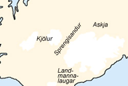
Kjölur

The route over the Kjölur is already known since the time of the settlement of Iceland as inland passage. The old riding path ”Kjalvegur” runs west of today’s street (F35). In the 19th century this inland passage was almost forgotten after a farmer’s son and his servant had come to death in October 1780. After a sheep pest in northern Iceland they had bought 180 sheep in the south, which they wanted to bring home into the north before winter. A search in the same autumn remained unsuccessful. Only in the next spring the bones of their horses and sheep were found on a hill south of Hveravellir. Since then this hill is called Beinhóll (Bone Hill). A memorial is standing here today, that reminds on the fatality. From the jeep piste this hill can be reached after a 7 kilometer march on foot.
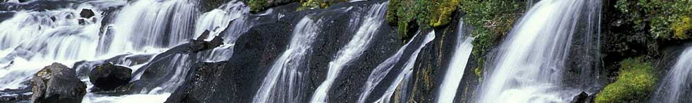
The old Kjalvegur was newly marked with stone look-outs by the Iceland fan Daniel Bruun at the end of the 19th century. From then on it was possible to cross the highlands on horseback in four days in a relatively safe way. Today all rivers along the jeep piste F35 are bridged. The southern half is more interesting than the northern part, however it has many potholes. The northern half partially has a similar quality as the ring road. The clou of the 190 kilometers long highland crossing is Hveravellir. This is one of the biggest and prettiest geothermal areas of Iceland and is located half way through the trip. After a short march on foot one reaches a small cave, in which the famous outlaw Fjalla-Eyvindur is meant to have lived for many years in the 18th century. The visitor has the opportunity here to have a bath in one of the hot springs.
A detour to the Kerlingarfjöll - a small ford has to be crossed - is very recommendable. In these Ryholith Mountains a breathtaking landscape awaits the visitor. Innumerous hot springs steam here underneath a glacier tongue. In the souther part of the Kjölur route one drives past the 30 square kilometer big glacial lake Hvítárvatn. Into it calves a glacier tongue of the Langjökull.
Delinquent-Desert Ódáðahraun
North of the Vatnajökull lies Iceland’s biggest connected lava field - the Ódáðahraun. It is also known as the ”desert of the delinquents” and comprises an area of about 4,500 square kilometers, which is abut the size of the German Saarland. Delinquents fled here in the Middle Ages, that had been declared as outlaws at the Althing. The most famous outlaw was Fjalla-Eyvindur. He spent 17 years with his wife in the highlands until he was finally pardoned and was allowed to return to society. Especially cyclists and hikers should care for sufficient drinks and food on a corssing. Also the traveller always has to account for sand and dust storms in this area. In the 1960’s, American astronauts heading for the moon were trained for geological research in this area.
Askja and Herðubreið

Especially cyclists should care for sufficient food and drinks if they want to enter the solitude in the eastern highlands. Also the traveller always has to account for Sand and dust storms in the area of the Delinquent-Desert. Coming from the Mývatn on the western route to Herðubreið and Askja one has to cross 2 rivers and a lava field of four kilometers length. The fords on the eastern jeep piste to Askja are smaller and also the road is easier to drive. Partially however it is very sandy. Cyclists can only advance slowly here.
Through screes and moon landscapes one reaches the great caldera Askja. This volcano was last active in 1961; 11 square kilometers of land were covered with lava during its eruption. The 600 square kilometers big Dyngjufjöll-Massive with the Askja is around 4,500 years old and has accrued through many such volcanic eruptions. The Askja caldera itself has a spread of about 45 square kilometers.
Through a mighty explosion the Vítí crater was born in 1875. Following this eruption the ground south west of the Vítí has sunk further, filled with water and formed on this way with 230 meters depth the deepest lake of Iceland – the Öskjuvatn.
The collected water in the explosion crater Vítí is warmed by hot springs and invites for bathing. The descent to the crater lake however is very steep and slippery. In 1907 an accident happened in the Askja. The German geologist Walther von Knebel had travelled here with his student Hans Spethmann and his friend and artist Max Rudloff to explore the volcano massive. Since July the 10th of that year Walther von Knebel and Max Rudloff are missing. Their destiny is unknown until today. Both explorers probably drowned in the lake Öskjuvatn during their research work. To honour them the lake therefore is also called Knebel-Lake, and the explosion crater Vítí Rudloff crater. Spethmann, who on this day explored another part of the Dyngjufjöll Mountains, was the only surviver of this three-man expedition. A memorial tablet at the edge of the Öskjuvatn reminds on the casualties.

On the way back to Mývatn the traveller passes the beautiful mesa Herðubreið (1,692 meters), the queen od the Icelandic mountains. In the god teachings of the vikings it was assumed that the castle of the gods must be located here. This part of the highlands comes across to the visitor as an oasis. Hikes are also possible here.
The ascent of the Herðubreið should only be attempted by exerienced alpinists. The first ascent of this highest mesa in Iceland was successful the first time in 1908, made by the German geologist Hans Reck and his Icelandic companion. Hans Reck was together then with Ina Grumbkow, the fiancée of the casualty Walther von Knebel, on an expedition to Askja on which they were also looking for traces of the missing German explorer.
Kverkfjöll

From the Askja it is not far anymore to the northern edge of the Vatnajökull. The gravel piste however is very exhausting to drive, even if no deep fords have to be overcome. Many hikes can be undertaken in the volcanic massive Kverkfjöll. In order to reach the hot springs however, a glacier tongue has to be crossed, which should only be attempted in good weather.
In the Kverkfjöll area many hot springs have formed numerous ice caves underneath the ice of the Kverkjökull. Their condition changes constantly, so that a walk through the caves is not advisable, as big blocks of ice could break off the ceilings. From Akureyri and Mývatn three-day tours to Askja and Kverkfjöll are offered regularly. The nights are spent in either a hut or on the camping side.
Landmannalaugar
North of the glacier Mýrdalsjökull is an area with colourful mountains, a hot river and ”the hot springs of the country people” - so the translation of Landmannalaugar. Many hiking paths pervade these 600 meters high Rhyolith Mountains. The red colouring of the mountains indicates a high iron content, yellow indicates sulfur and turquoise silicia. The area is one of the most visited in the Icelandic highlands. Even in the early morning one is not undisturbed during a bath in one of the hot springs.

The northern route to Landmannalaugar can be overcome without problems with an off road vehicle or bicycle. Coming from the south the traveller has to cross many fords. The stream just before the camping side in Landmannalaugar is partially very deep (up to 80 cm) and can often only be crossed by big vehicles. In this region one can undertake many hikes of different durations. Also the most popular several day hike across the Laugarvegur starts in Landmannalaugar and leads in four day stages to Þórsmörk. The nights can be spent in huts of the Icelandic hiking association. A pre booking is very recommendable.
Eldgjá
If one drives from Landmannalaugar southwards one comes across a dead-end to the volcanic fissure Edgjá. With breaks it is 30km long and with that the longest volcanic rift in the world. The eruption happened in 934, during which about 9,000 cubic meters of lava escaped and spread on an area of 900 square kilometers (Eldhraun). These numbers however are still controversial, as a big part of the ejected masses were covered by later eruptions, especially those of the Laki rift (1783/1784). Worth seeing is the waterfall Ófærufoss. A basalt bridge spanned over the middle level of the waterfall until 1993. Unfortunately it has collapsed by now.
The Laki Craters
From the ring road on the south coast a highland piste leads near the village Kirkjubærklaustur to the volcano craters Lakagígar (Laki-Krater). These are located between the glaciers Mýrdalsjökull and Vatnajökull. The about 40km long road is opened in summer for highland suitable vehicles. The Laki-Craters accrued through several, very lava rich eruptions in 1783/84, during which more than 100 craters were active at the same time. This lava richest eruption in historical time had disastrous effects for the population. The gases freed during the eruptions infected wide parts of the fertile southern land. Thousands of farm and grazing animals died, which brought great famine to the people. Around 20% of the population - then around 10,000 people - died from starvation, so that the Danish king even considered to evacuate Iceland and give up this island.
The eruption also had consequences in Europe and North Africa. As an climatic result of the eruption the temperature on the northern hemisphere cooled down by one to three centigrade. Especially the winter of 1783/84 was extraordinarily cold. According to today’s estimates 16,000 to 20,000 people could have also died in France and England through the air pollution and extreme temperatures.
In 1783 and in the winter of 1783/84 the death rate alone in these two countries was higher by 25%, according to reports from that time. Because of the low temperatures the water levels of the Nile reached a low, which was folloed by a great famine and 17% of the population in the catchment area of the longest river of Africa died. Today around 130 craters string together on like on a pearl necklet on a length of 25 kilometers. These craters can be visited on a day trip from Kirkjubærklaustur by off road vehicle or bus.