Sights in East Iceland
Vatnajökull

The Vatnajökull is with 8,300 square km Iceland’s biggest glacier. It covers about 8% of Iceland and the ice is in some places up to 1,000 meters thick. Therefore the Vatnajökull is also the biggest glacier of Europe, and after Antarctica and Greenland’s inland ice the third biggest connected ice compound in the world. The mighty ice armour hides underneath whole valleys and mountains – but also active volcanoes.
And here, in the most active volcanic area of Iceland, here are the continuous eruptions underneath the glacier that Iceland is famous for. The ice cap prevents destruction through big lava masses, however when the magma melts the ice it can lead to enourmous floods. This happened after the eruption of Bárðabunga in autumn 1996. In the Sander area south of Vatnajökull, where usually only a small runlet flows, the glacier run had reached its maximum flow conditions of 45,000 m³/s on 6th November 1996. The most important circular road of Iceland was completely destroyed.
Another feature of the Vatnajökull are the Grimsvötn under the western part of the ice cap. Lakes have developed here through hot springs under the ice. A similar phenomenon one can find at the northern edge of the glacier. In the Kverkfjöll massive hot springs have made numerous ice caves.
Skaftafell

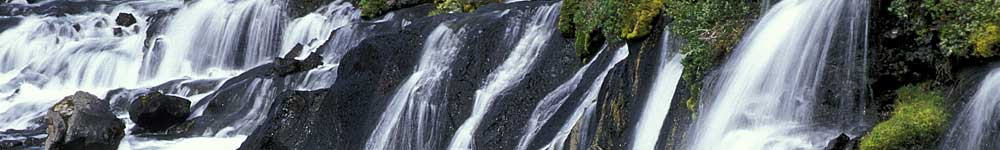
Protected against wind between high mountains lies Skaftafell. The 1967 built national park offers a ample vegetation, exceptional for Iceland. The view on the big glacier tongues of the Vatnajökull and numerous waterfalls invite to a small hike. Beginning at the tourist center, past the camping area, a path leads to the only twelve meter high Svartifoss (about 45 mins.). This pretty waterfall belongs to the main attractions of the park. When following the path further, one has an impressive view onto the glaciered Hvannadalshnúkur, which is with 2,119 meters the highest mountain of Iceland.
In 2007 the up until then second biggest Skaftafell national park was expanded and renamed. The new park called Vatnajökulsthjódgardur (Vatnajökull national park) ranges now over 1/8 of the total area of Iceland and reaches from Skaftafell over the Vatnajökull to the Jökulsárgljúfur national park in northern Iceland. Vatnajökulsthjóðgardur is now with an area of around 12,000 square kilometers the biggest national park in Europe.
Glacier lagoon Jökulsárlón

The glacial lagoon Jökulsárlón is located between the Vatnajökull and the sea, not far from Skaftafell. Through the retreat of a glacier tongue of the Vatnajökull a small fjord has accumulated here, which is not filled with sea water, but with melt water of the Vatnajökull. Blocks of ice fall again and again into the melt water and are then transported via a not very long river into the sea. Also when it does not seem so: the few hundred meters long river and the only 8 square kilotmeter big lake reach a depth of over 160 meters in some places.
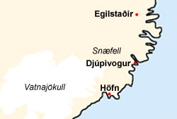
The East Fjords
The Centre of the eastern fjords is the city of Egilsstaðir with its 1,600 inhabitants. The first house was errected here in 1944, however since the construction of the inland airport and the connection to the ring road this place hasbecome the most important hub of the east. The ferries, arriving from the European mainland, stop in Seyðifjörður, however the first contact point for tourists is mainly Egilsstaðir. The city does not offer many places of interest, however it is the first starting point for many day trips in eastern Iceland.

Directly by Egilsstaðir lies the Lögurinn lake, the third biggest lake of Iceland. It reaches because of its maximum depth from 112 meters to 90 meters underneath the sea level. The wooden area on the east side of the Lögurinn is striking. Already at the end of the 19th century the reforestation of Iceland has started here. In 1905 this area was placed under conservation. Today the visitor finds in this biggest wood of the northern atlantic island plants from northern America, Europe and Asia. On the southwestern side of the lake leads a small path upwards to the third biggest waterfall of the country – the Hengifoss (118 meters). On the way there once passes also the waterfall Litlanefoss which is decorated with basalt columns.
The east of Iceland is geologically relatively old. It offers no spectacular tourist attractions, such as solfataras and geysers. But for visitors with an interest in geology trips into the deep fjords are offered, for example to Borgarfjörður Eystri, where one comes across some places of fossil findings.
With an off road vehicle a trip to the eastern highlands is also possible. A destination is very often the snow covered mountain Snæfell, which towers, visible from far, over the plains. From the same highland piste are connections to Askja and Kverkfjöll in the eastern highlands. These destinations, however, are not suitable for day trips from the eastern fjords and are only accessible with a good off road vehicle.