Sights in North Iceland
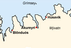
Lake Mývatn

The area around the lake Mývatn is known as the sunniest place in Iceland and famous for its rich bird avifauna. The many midges, that gave the lake its name, are for fish and birds a welcome prey. Also the visitor of this idyllic lake comes into close contact with this pest. Even though the insects do not bite, they have the inevitable urge to crawl into every orifice they can find! At certain places and times it is therefore wise to wear a mosquito net around the head.
The midget lake accrued about 3,800 years ago. However, only through the volcanic eruption about 2,000 years ago (younger Laxálava) the 37 square kilometer lake received its present appearance.
The pseudo craters south east of the lake are striking. The are not connected to a magma chamber, but accrued when hot lava flowed over wetland. The gaseous water, lieing underneath the lava, ecaped when it pushed the lava explosively upwards. This way little crates mounted up. Moving further north of the pseudo craters, one reaches after a few kilometers the also very worthwhile destination Dimmuborgir. These rock formations accrued about 2,000 years ago when a natural dike stopped a flow of lava. A few parts of the lava flow cooled down and solidified in bizarre forms. These unique lava formations - Dimmuborgir, the "gloomy castles" – stayed when the dike broke and the still fluid lava could leak.
About 500 years prior to the effluence of the younger laxálava, the ash crater Hverfjall, located east of Mývatn, accrued in one single explosion. It rises 150-200 meters over the plain and is probably the most distinctive mountain in the closer surroundings of the lake. A small hike leads up to the edge of the crater. From there one has a very good view onto the 140 meter deep and about 1 kilometer wide crater. In good weather conditions one also has a great view onto the Mývatn area and to the volcano massive of Krafla.

The caldera of Krafla (818 meters) with its "hell crater" Vítí lies only a few kilometers away from the lake. The Krafla region is pervaded with a cluster of volcanic rifts, which made headlines in the 70ies and 80ies. Over a period of nine years several eruptions happened, which went down in Icelandic history as the Krafla fires. Already in the 20ies of the 18th century the explosions of the Vítí crater, the so called Mývatn fires (1724-1729 and 1746), were triggered.
A bit further east of the Vítí extends the jet black lava flow of the earlier mentioned Krafla fires from the 20th century. On a one hour walk around the top of the Leirhnjukur this lava field can be visited. The way also leads past a few solfataras.
If one drives from Mývatn towards the North, after a mountain crest one comes across Námaskjað, one of the biggest solfatara fields of Iceland. Hot springs and simmering mud pots can be admired here. In the 18th century sulphur was mined here and exported to Denmark to be made into gunpowder. At that time Denmark was going to war against Sweden.
On the western side of Mývatn one can watch birds very well, as all of the waterside northwest of the lake has been declared a bird sanctuary. The Mývatn is especially famous for its many ducks. All of the on Iceland occuring species breed in this region. Those who want a beautiful view onto the whole Mývatn region can explore the mountain Vindbelgjarfjal on the western border of the bird sanctuary. The hike starts at the road by Vagnbrekka.
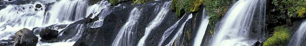
Dettifoss

The glacial river Jökulsá á Fjöllum, coming from Vatnajökull, forms on its way north many waterfalls and a canyon like gap. The most famous waterfall on this glacial river is the 44 meters high Dettifoss. With an average waterflow of 200 m³/s it is the mightiest waterfall in Europe. In summertime the river reaches a waterflow of over 1,500 m³/s. In the very grey coloured water one can recognize the enormous amount of sediments, which the river carries with it. It transports per hour around 120 tons of rubble.
A few hundred meters further up river lies the smaller, yet very pretty waterfall Selfoss. Both waterfalls can be visited from the east as well as the west side of the river. The road west of the river however is in some places only drivable by 4-wheel-drive vehicles.
Ásbyrgi
North of the Dettifoss lies the 3.5 kilometers long, horseshoe-shaped canyon Ásbyrgi. According to a descent this is a hoof imprint of Odins eight-legged horse Sleipnir.
Actually though this canyon was made from melt water of two rivers, which formed the two northern gorges. With continuing erosion the rivers dispaced their position southwards and bundled to a big stream, which connected the already accrued gorges. In the southern part of Ásbyrgi a waterfall fell around 2,000 years ago over the up to 100 meters high, vertical rock faces and formed the now horseshoe-shaped canyon further. Ásbyrgi lies relatively safe today and offers the visitor ample vegetation. From the southern campsite one can climb the rock ridge Eyjan via a path.
Húsavík

In the year 850 b.c. the swedish viking Garðar Svavarsson overwintered in this bay on the the peninsula Tjörnes, who built the first house on Iceland - therefore it is named Húsavík ("House Bay").
At his departure he left one companion and two slaves behind. As their stay was involuntarily and their social position was less respected at that time, they did not count as the first settlers of Iceland.
Húsavík is an old trade center, in which the first association of the country was founded in 1882. Today the village counts around 2,500 inhabitants. Striking is the 1907 completed, 2 storey Húsavikurkirkja, the church, which is different to the traditional small Icelandic churches through its green roof and the square, 26 meter high bell tower. The chapel offers seats for 450 persons. Since 1982 the church is a listed building.
Worth seeing is also the local museum of local history. One of the most valuable exhibits is a reproduction of the Gudbrandur-Bible from 1584. In addition a stuffed polar bear can be viewed here, that came from Greenland to iceland on an ice floe in 1969 and was shot on the island of Grimsey. A visit to the whale museum is also worthwhile. Here the visitor learns a lot about the sea mammals living around Iceland. There is a reason that this museum was established in Húsavík. The village has become famous for whale watching boat trips. Whales and dolphins are sighted on more that 98% of these trips. By now Húsavík is one of the big European metropolises for whale watching.
Goðafoss
The Goðafoss falls 12 meters into the deep directly next to the ring road between Mývatn and Akureyrí. The waterfall owes his name to the goden and legal spokesman Thorgeir, who voted on the annual meeting in Thingvellir in the year 1000 for the implemention of Christianity. After the implemented Christianisation of the Icelanic population Thorgeir threw his old god and graven images into the floods of the waterfall. The Goðafoss is one of the most beautiful waterfalls in Iceland.
Akureyri
Akureyrí is the fourth biggest city of Iceland and the only metropolis outside Greater Reykjavík. The ”Capital of the North”, how it is called occasionally, is the administration and service centre of Northern Iceland. Although only around 15.000 people live here, it offers an infrastructure that probably cannot be found in a City in Central Europe of similar size. In the 1980s for example the second university of the country was opened in Akureyri.
At the beginning of the 20th century the city only had 1,300 inhabitants. After the founding of a trading company (KEA) in 1886 Akureyri gained importance. Worth seeing is the 1940 inaugurated church. It is the symbol of the city and has been constructed to honour Matthias Jochumssons – a priest and poet, who also wrote the text of the Icelandic national anthem. Also worth a visit is the 1912 founded botanic garden. Here one can find almost all local and numerous foreign plants.
The Vatnsnes peninsula
A detour from the ring road leads to the peninsula Vatnsnes, which reaches a bit into the Húnafloi bay. It can be discovered via the well finished gravel slope Nr. 711. On its east coast one can find the basalt rocks Hvítserkur that tower 15 meters high out of the water, which is hollowed out by the surf in 2 places. If one believes a folk tale, this rock once was a troll, which was turned into stone by the sunlight. At the cape of the peninsula is Hindisvík (Seal Bay). All over the year one can view one of the biggest seal colonies of Iceland.
Also the area south of the peninsula, between Brú (near Hrútafjörður) and Gljúfurá (on the way to Blönduós) has a lot to offer. For example one can find here the only museum for shark catching. Further activities in this region are for example the bringing down of the sheep and horses from the fields in autumn and unique riding trips (starting at farm Brekkulækur). A bit further south is one of the biggest, connected wetland of the North – the Arnarvatnsheiði with excellent salmon trouts. The annual Grettir-festival in August is also an event worth visiting. Here everything deals with the famous Icelandic Saga of Grettir the Strong.