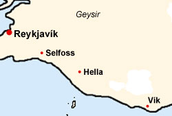
Sights in South Iceland
Some of the most importand sights of Iceland are situated in the south of the island. On this page we give a short overview on some main attractions. Further sights in south Iceland you'll find in our large photo galleries on South Iceland as well as the south coast.
Thingvellir

Thingvellir is historically, as well as geologically and interesting destination. At the mile long rift one can see clearly how the tectonic plates of Eurasia and America drift apart – on average about two centimetres annually. The waterfall Öxaráfoss falls 12 meters into the deep over the tectonic plates near the medieval parliament square of Thingvellir.
A great part of the Icelandic history has taken place in Thingvellir. In the year 930 the Icelandic people gathered here and established one of the first free republics in the world. Once a year the Althingi, a traditional legislative assembly, that had legislating as well as jurisdictional functions, held a meeting. Every Icelander could state their concerns and demand a court decision. The two-week meeting, however, was also celebrated as a kind of folk festival, at which also marriages were agreed. Also in modern times important events took place at this historical location. So for example was today’s Republic of Iceland announced in Thingvellir on 17th June 1944.
The plain near Thingvellir was made into a national park in 1928, and in summer 2004 the UNSECO declared the historical place a World Heritage Site of mankind.
Geysir

"Geysir" actually is the proper name of one specific spring in Haukadalur (Hawk valley) and means something like "sputtering". This spring gave its name to all the others of its kind. The geyser hat stopped its activity at the beginning of the 20th century. Through severe earthquakes in June 2000 the big geyser became active again and erupted since then again occasionally. By now however, its activity has become rare again. Considerably more reliable in its activity is the little neighbour of the geyser - the Strokkur (Butter Barrel). In regular intervals of about 10 minutes it throws water and steam up to 25 meters into the sky. The German Chemist Robert Bunsen explained the functionality of geysers scientifically for the first time in the 19th century. He explained to himself this phenomenon in the way that the far over 100°C hot water in the geyser shaft was abruptly brought to a boil through a sudden pressure discharge. The upwards-aiming steam pulls the above water column into the sky.
Gullfoss

The majestic Gullfoss (Golden Waterfall) clearly counts to the most beautiful waterfalls of the country. The Hvítá (White River) falls over 2 cascades 32 meters into the depth here. The average flow condition at this part of the Hvítá is 109 m3/sec. During the spring melt and with concurrent high rainfall the body water can reach up to 2,000 m3/sec. In the further course the river has dug a 3-4 km long canyon, which in some places is up to 70 metres deep.
In 1970 the Icelandic government dismissed a law (Fossalög) to protect rivers and waterfalls from being bought for energy generation by foreign companies. However, the law proved itself as insufficient as Icelandic corporations could gain the usage right for the rivers and waterfalls, but foreigners could still buy the purchase of shares in these companies. Reason for the legislative policies was the fact that in the years 1906-1907 and Englishman was anxious to make the waterfall Gullfoss his property. It is thanks to Sigriður Tómasdóttir, the daughter of the here resident farmer of Brattholt, that no power plant is built at this unique and beautiful waterfall. The Gullfoss and his close surroundings are placed under nature conservation in 1979.
Hveragerði
Hveragerði, the garden of the hot springs, is characterised through its many greenhouses. In them sprout numerous tropical plant and all kinds of vegetable. So, for example, one can find in the city with the 1,700 inhabitants the northernmost banana in the world. The first greenhouse by the way was not built by an Icelander but by a German gardener. In the easternmost part of the city also stands a clinic of the Icelandic naturopathy association that offers among other things mud and sulphur treatments.
Hekla
Iceland’s probably most famous volcano is the Hekla. The name means something like ”cap” as the mountain is always covered by a snow cap. One assumed in the Middle Ages that this is where the entrance to hell is located. There is evidence that back then already one feared the eruptions of this volcano. In 1104 an outbreak destroyed numerous farms and made the surrounding grassland unusable. At this time Hekla began a geologically new phase in its activity. Since then it is in the change from a rift volcano to a strato-volcano. An ascent is possible, yet takes some time.

Þjórsárdalur and surroundings
The valley of Þjórsárdalur is in the northeast of Iceland’s south. The valley is famous for its many archaeological excavations of old farms, which have been buried through the enormous eruption of Hekla in 1104. The excavation site of the farm Ströng, which’s ruin is canopied and free for sightseeing, is especially worth seeing. From here one can undertake a few hikes into the Þjórsárdalur. The paths are leading through unusually ample vegetation to numerous waterfalls, which are surrounded by artful basalt columns, like for example in the canyon Gjáin and the waterfall Hjálparfoss south of the main road. A hike to the second highest waterfall of Iceland, the Haífoss, demands some experience. Occasionally once has to wade through streams on this about five hours long hike.
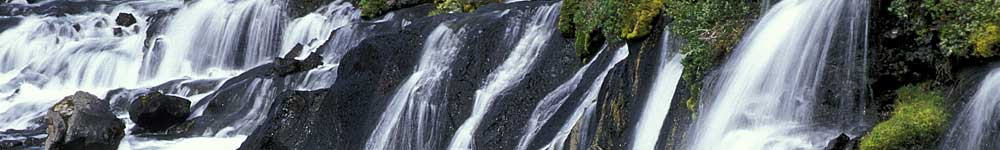
Seljalandsfoss and Skógafoss

The characteristic of the pretty 65 meters high Seljalandsfoss is an indentation in the rock face behind the waterfall. This indention allows the visitor to get behind the waterfall on a little bit of a slippery way. However, it must be warned about making such a walk behind the much more powerful Skógafoss (height of fall 62 meters) which rushes down over a former cliff a few miles east. A valuable gold treasure is meant to be stored behind the waterfall according to legend. It almost seems as if one could see the gold shining behind the waterfall in the noonday sun in form of a colourful rainbow.
Many Icelandic toponymies point out the thoughtless uprooting through the first settlers in the 9th and 10th century. Some places, like for example the Skógafoss (”waterfall”) as well, which because of their names indicate wooden areas (-skógur, -mörk, -holt) are only covered by scarce vegetation today. The areas were given these names during the time of the land grabs. However, shortly after the settlement already some huge parts of the Icelandic tree population were being uprooted. Especially to work against the severe eruptions, one started in the last few years with the reafforestation of Iceland through large-scale projects. A visit to the museum of local history in Skógar should not be given a miss. The director of the museum, Þórður Tómasson, enjoys explaining some of the pieces of his collection to every visitor. Already at the age of 14 he began to compile these valuable pieces of Icelandic history. For 600 ISK (about 5.00 GBP) one can view more than 6,000 exhibits from past times. The appendant open-air museum offers an insight into the way of life of the Icelanders in the past centuries.
Vík í Mýrdal

The village Vík, counting 350 inhabitants, lies at Iceland’s southern tip. According to a US magazine this is where one of the ten most beautiful cities in the world is located. The ”Black Beach” with its rich bird life does belong to the highlights of the Icelandic southern coast.
The mile long sandy beach and the local cliffs invite to dwell here. Since September 2002 a memorial is located here, which was erected together with the German navy museum in Bremerhaven and remembers the 1,000 seamen, which lost their lives on fishing boats in Icelandig waters. At the same time it is meant to thank the numerous Icelandic helpers, who always took care of the casualty fisherman and could save many lifes.