
Hiking in Iceland
Some ideas for hiking and walking in Iceland
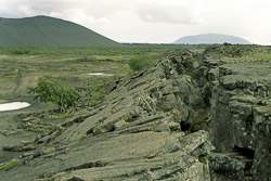
Skógar - Fimmvörthuháls - Thórsmörk
Eight-hour hiking between waterfalls and glaciers

Starting point of this long and demanding hiking is Skógafoss at the south coast. On the right-hand side of the waterfall exists a steep path with steps upside the hill. You reach a cottage near the Fimmvoerthuháls after approx. four hours where you can rest for a while. In the region of the pass the path goes parallel to several snow pads where you can loose orientation very easily during bad weather and sight. While descent into the Thórsmoerk valley the path is interupted for one stead. Accomodations exists in Skógafoss (camping site/hotel) and Thórsmörk (Básar cottage/camping site).
It is also possible to split the tour on two day trips and spend the night in the cottage near the Fimmhoerthuháls. The difference in altitude accounts for 1100m.
Landmannalaugar (Laugavegur)
The classic route of the Icelandic hiking track
Landmannalaugar is one of the most beautiful areas of the Icelandic highland. Huge variety of hiking oppportunities could be found in this region - a short walk or even a hike for several days, everything is possible. The following tours take some hours to walk and can also be combined with each other in half or full day trips:
- Solfataras of Brennisteinsalda
- Mountain Bláhnúkur
- Canyon Brandsgil
- Peak of Suðurnámur
But the one of the most popular hiking trails in the Icelandic highlands is the trail “Laugavegurinn”. The total distance is more than 50 kilometers and the tour follows a path from Landmannalaugar to Thorsmork. Accomodation in mountain huts. Please contact a tour operator for guided tours and reservation.
The old Kjalvegur
Follow in the tracks of the ancient highland route
The old Kjalvegur was already used for crossing the highland by the Kjoelur in the Middle Ages. Nowadays the highland track F35 is running a little bit more eastern than the medieval bridle-path. The southern track from the Hvítárvatn to the Hveravellir could be striked out in a relaxed pace within three days. Here, of course you could find again cottages of the Icelandic rambling club. During the summertime it is badly necessary to reserve one of those cottages before you start the trip. A quartan tour including the voyage out and return journey from/to Hvítárvatn could be booked by the BSÍ at the bus station in Reykjavík.
Reykjalið - Grjótagjá - Hverfjall - Dimmborgir
Ash cone and dim castles
This hiking track is leading along some of the most important sights of the Mývatn area. After the bifurcation of the road 1 at Reykjalið to Egilsstaðir the four hour lasting trip begins. You reach the grotto Grjótagjá after crossing an old lava field and lush vegetation. The water temperature in the grotto has risen since the Kafla erruptions of the 1980’s very strongly and that’s why bathing is not possible anymore. Vis-à-vis of the main entrance of the grotto a path leads through lowlands to the ash crater Hverfjall. Just before reaching the crater you must get over a fence before you start the climbing the extinct volcano.
The altitude difference measures 150 meters, but it is easy to reach the crater border. There are another 150 meters ascent starting from the crater rib until the southern edge is attained. From here there is a beautiful sight down to the one kilometre wide crater as well to the western situated Lake Mývatn. The descent is steep and sandy, but it is no problem even for inexperienced hikers. You reach Dimmuborgir after few minutes. Walking along the road you reach the starting point of your hiking trip.
From Leirhnúkur to Reykjalið
Trail along solfataras
The bus consorts twice a day between Reykjalið at the Lake Mývatn to the explosion crater Vítí in summer. But passangers already get out at the parking lot Leirhnúkur and start there the fife hour lasting hiking trip back to Reykjalið.
The denoted path starts directly at the parking lot and leads after 15 minutes of walking to the mountain Leirhnúkur. However you do not exactly go in the direction of Reykjalið, but orient yourself towards the tour around the peak. The path is along solfataras and is leading through some lava field of the Krafla eruptions of the years from 1975 to 1984.
Instead of hiking south of the Leirhnúkur back to the parking lot, hikers now pursue into the direction of Reykjalið. On your way to Reykjalið you will pass the lookout mountain Hlíðafjall. If you want to climb the peak you have to mind that the ascent is partly ardous. The descent leads back on the same path used for ascent. Along the Eldá lava which is dating from the 18th century the path ends in Reykjalið at the camping site.
Pseudo craters next to the Mývatn
Go for a walk at the lake
On the southside of the Mývatn (“midge lake”) the short walk starts opposite of the cafeteria. The path is partly leading around the lake and partly leading up to some pseudo craters. This beat is lasting about half an hour.
The seal bay
Where you can watch seals without fail
The seal bay (Hindisvík) is situated on the northern head of the peninsula Vatnsnes in Northwest Iceland. Meeting seals here is likely. The path is starting at the road 711 and is leading directly to the bay. Walking time amounts about half an hour.
Eldborg
Way up to the volcano in the east of the Snaefellsnes-peninsula
Lasting 45 minutes each direction the ascent of the hillfort volcano Eldborg in the east of the Snaefellsnes-peninsula is relatively easy to manage. Starting point is the farm Lindartunga situated near the road 54. First of all the path passes a lava field covered densely with shrubbery. Merely the final metres of ascenting the crater can be a little bit slippery. After reaching the crater edge visitors have to be careful as the crater rib is slim at the top, but steep to the bottom!
Glymur
Round hiking trails to the second highest waterfall of Iceland
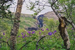
Starting point of this three-hour hiking tour is the parking place of the nature reserve Storibotn at the end of the whale fjord "Hvalfjörður" in West Iceland. The parking site is attainable by the gas station Botn (2.5 km). The climb begins at an iron bridge and the path leads through undergrowth uphill. Further above the shallow brrok Botnsá must be wade through.
After crossing an area with squishy ground you reach a ravine, which you have to follow southward. The waterfall Glymur can be seen from three viewpoints in the ravine. At the end of the ravine a very cliffy path leads to the river coming from the waterfall. You reach the other side of the ravine by passing a bridge. From there you reach a driveway after some minutes, on which you arrive back at the parking site.
Látrabjarg
Short walk or 3 days hiking tour

The westernmost point of Europe is situated at the steep cliffs of Látrabjarg in the west fjords. These extend over a length of approximately 14 kilometers. Here you can hike as long as you want - one hour or several days. From the parking site at Látrabjarg a path leads up to the 450 meters high bird rock toward the east. There is not a round way unfortunately, so that one must walk back on the same path.
However it is possible to go for a three days hiking tour from the hut in Keflavík (accomodation) to the sandbanks of Rauðasandur, where you find another hut near Melanes (accomodation). On the third day the path leads across the high plateau of Sandsheiði and ends at the crossroads 62 and 611 near the Barðaströnd.
Vestmannaeyjar
Puffins and volcanoes

The path along the west coast of the island Heimaey begins at the golf course in the valley Herjólfsdalur and leads up to the lighthouse Stórhöfði at the south point of the island. The Westman Islands are well-known for their large puffin colonies. Along this hiking trail numerous birds of this species can be observed. In particular at the south point of the island are enormous colonies. The way is approximately six kilometers long. The way is approximately six kilometers long. Altitude differences only excist in the south when ascending toward the lighthouse.
Another short walking-tour on Heimaey with more altitude differences leads to the 5,000 years old volcano Helgafell or the new volcano Eldfell, which was created during an eruption in 1973. The path to the 226 meters high Helgafell is signposted and begins in the southeast of the village. You can descend the mountain at the northwest slope of the volcano. Between Helgafell and Eldfell you reach a signpost, which shows the way up to Eldfell.
Booking a trip
Our partner GetYourGuide (Ad) provides several trips from Reykjavik and other places in Iceland.